Compass Cave Survey Software Logo - Bats, Compass and Night Sky
Custom Search
 
 Sponsored Links


COMPASS For Windows
Compass Tour
Other New Features
Cartography Tools
Live 3D Cave Images
On-line Help (New)
Written Description
Revision History: 99-21
Testimonial Letters
Contact Author
Getting COMPASS
Getting Compass
Compass On A CD.
Download/Install Issues
Installation Instructions
Antivirus Issues
Authenticating Files
False Positives
Registration Information
Credit Card Reg.
Reg. Info/Forms
Printable Reg. Form
3rd Party Reg. Form
Auxiliary Tools/Information
Cave Data
3D Glasses
ESRI/ArcView Tools
Tutorials - (New)
Inkscape Tips and Tricks
Radio Locations
Magnetic Anomalies
Installing Under Win8
Compass on A Mac
Google Earth Overlay
Declination/Convergence
Cartography Tools
Sketch Editor.
SVG Export
Inkscape SVG Maps
Illustrator SVG Maps
SVG Round Tripping
Adopting SVG Maps
Complex Plot Tutorials
Trouble Shoot CaveX
Exporting HPGL
Canvas Digital Map 
ArcView/ESRI
Italian Tutorial
Using the Compass CD
DEM Tutorial
Links
Cave Related Links
User's Pages
User's Group
User Questions
Documents/White Papers
Compass File Formats
ArcView/ESRI
Finding Blunders
Finding Loops
Loop Closure
Least Squares Papers
Least Squares Issues
Passage Modeling
Survey Blunders
J. Halleck- On Loops
History/Philosophy
SEF File Format (1992)
About The Author
COMPASS For DOS
DOS Compass Demos
DOS Compass Features
Magazine Review
MISC.
Other Products


Compass Sketch-map Editor - Tutorial

Next >>
Preparing Sketch-maps. Most cave cartographers map the floor detail and passage walls through small, hand-drawn sketches of the cave. Depending on the size of the passages, each sketch typically has three or four shots, so there may be dozens of 
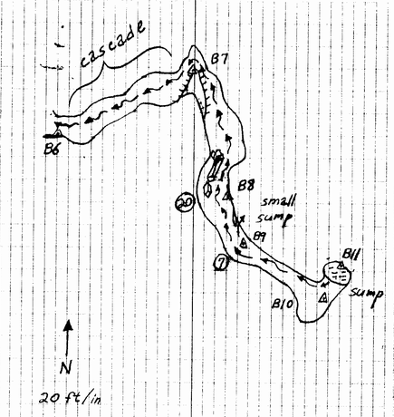
sketch-maps for each survey. The image to the right is a typical example from the 1987 survey of Fulford Cave.

These images can be scanned into a computer and then traced in a drawing program such as Inkscape or Adobe Illustrator. They can also be manually traced. Unfortunately, inconsistencies in the scaling and rotation can make the process tricky and difficult. In addition, working from dozens of small maps can make the tracing process tedious. Finally, small errors in the sketch-maps can put the stations in the wrong place relative to the plot of cave, forcing the cartographer to fudge the positions manually.

To solve these problems, the Compass sketch-map Editor allows you to scale, rotate, merge and morph the images to match the true positions of the survey stations. To help you get acquainted with the process, I have written this tutorial that will walk you through the whole process.
Compass Tutorial. The Compass sketch-map Editor is a set o special tools designed to prepare your sketch-maps for manual tracing or digital tracing in programs like Inkscape or Illustrator. To illustrate this process, we will walk through the process of editing sketch-maps for the "B" survey in Fulford cave. (Fulford is a wild cave in Colorado that is on Forrest Service land and open to the public. The Compass distribution contains a copy of the Fulford Cave survey data. )
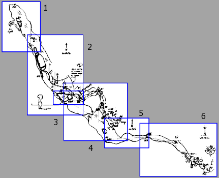
Overview. The "B" survey in Fulford consists of six sketch-maps that cover all the passage walls and floor detail. The image to the right shows how all the images should be combined to form a single, continuous image that makes it easy to trace the passages when we make the final drawing.

The process consists of six steps:

1. Scale. In this step, we adjust the images so they are same scale and at a useable size.


2. Trim. In this step, we will trim off excess parts of the image, so we only have the passage and floor detail.
3. Rotate. In this step we remove any residual rotation so the passages are perfectly aligned to north.

4. Preliminary Morph. In this step, we do a preliminary morphing of the passage. Morphing adjusts the image to match the survey station positions. The morphing process smoothly moves the passage walls and floor detail, so they track the survey station positions. Doing a preliminary morph on each individual image reduces the amount of distortion produced in the final morphing step.

5. Merging. In this step we merge all the images together to form a single, continuous bitmap.

6. Final Morphing. In this step, we morph the combined image to match all the station positions in the survey.

Tutorial Outline

I. Preparations. Preparing the sketches, plots and scanner for editing
  A. Prepare Plot File. Preparing the Compass plot files.
  B. Prepare Your Sketches. Preparing your sketches.
  C. Scan Your Images. Tips for scanning the images
  D. Run Sketch Editor. Running the Compass sketch-map editor
II. Editing Your Sketches Editing your sketches
  A. Loading An Image. Loading an image for editing.
  B. The Editing Tool. Overview of the Editing tool.
  C. Scaling. Scaling the bitmaps to precise, consistent scale.
  D. Trimming. Trimming excess information from the sketch image
  E. Flipping. Flipping the image so the north is always up.
  F. Rotations. Removing any residual rotation from the sketch
  G. Cleanup. Cleaning grid lines,
  F. Save Image  
III. Preliminary Morphing. Morphing the image to align it to the survey data.
  A. Load Plot File. Loading the survey plot file.
  B. Rotation. Dealing with declination issues
  C. Positioning and Zooming. Preliminary positioning and scaling.
  D. Set Precise Scale. Precise scaling to match the scanned images
  E. Select Survey Shots. Choosing individual survey shots for morphing
  F. Position Stations. Adjust station positions to indicate the position of errors.
  G. Morph Sketch Morph the sketch to correct station positioning errors.
IV. Repeat. Repeat steps II and III for all sketches in the survey.
V. Merging. Merge all the images in the survey into a single image.
  A. Load First Image. Load first or base image.
  B. Load Merge Image. Load image to be merged.
  C. Moving, Sizing and Rotation Adjusting the merge-image's position, size and rotation
  D. Image Transparency. Using the image's transparency to position the image.
  E. Auto Expansion. Auto-expansion of the image as the merge-image is positioned
  F. Final Positioning. Setting the final position and merging images.
  G. Merging More Images. Repeating steps B through F until all images are combined.
VI. Final Morph. Final morphing on combined image to remove residual errors.
  A. Morphing Combined Image. Morph the final, combined image to deal residual errors.
  B. Final Steps. Final Cleanup
  C. Tracing and Printing. Tracing and Printing Tips.
   

Next >>

 
 Sponsored Links
Sponsored Links
 Sponsored Links
 Sponsored Links

<< Home

Custom Search