A magnetic compass does not point to the true North Pole. The difference between true north and magnetic north is called declination. Declination varies from place to place and from year to year. Since cave surveys can take years to complete, these changes can cause distortion between old surveys and new surveys. As a result, Compass can adjust each survey according to the declination that was in effect at the time of the survey. Declination is entered as a part of entering the header of each survey. Declination values are always specified in degrees.
If you don’t know the Declination for the area you are working on, Compass can calculate declinations for you based on the location and date of the survey. Compass can also calculate declination “on the fly” while the cave data is being processed (See the Project Manager help for more information.)
How Declination Is Used. As Compass processes cave data, it reads the declination value for each survey and adjusts each azimuth by adding the declination value to it. This reorients the survey to the declination. For example, if a map shows the declination to be 13 degrees, it means that Magnetic North is 13 degrees to the east of True North. Thus when a magnetic compass is reading zero degrees, it is really pointing 13 degrees east of due north. Thus, by adding 13 degrees to the zero reading, the reading is converted to True North.
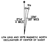
To illustrate this point, here is the declination information from a typical USGS topographic map of the Carlsbad Cavern area. As you can see, the Magnetic North is 10.5 degree East of True North. If you pointed your compass to zero, it would actually be pointing 10.5 degrees east of True North. This is why the declination value is added to the compass angle of each shot. |
|
Declination Range. Declination along the Mississippi River in the United States is near zero and ranges from 15 degrees on the West Coast to –16 degrees on East Coast. Declinations in Mexico, Australia, Eastern Europe and the Middle East are positive. Declinations in South America, Europe and Africa are negative.
Other Uses For Declination. You can also use the declination to compensate for different instrument settings. For example, Brunton Compasses have their own mechanical declination compensation devices built into them. If you use two Bruntons, one with the declination set to zero and the other with the declination set -13, data from the two will be incompatible. You can use the declination setting in the heading to compensate for the difference.