The Options Page controls all the basic complex plotting options. The details of these options are controlled on other pages.
Enable/Disable Complex Plotting. This option controls whether the display shows the Complex Options you've selected. If the option is off, the cave is displayed using the normal settings that you are using. If the option is on, the cave is displayed using the the complex option and settings you've chosen.
There are two basic kinds of Complex Options: Primary Mode and Exclusions.
Primary Mode. The Primary Mode options controls the basic coloring, labeling and marking of each passage. Only one Primary Mode options can be selected at one time. However, any combination of Exclusion options can be selected at the same time. This allows you to select combinations of coloring and exclusion that selectively display and highlight any part of the cave. Here are detailed descriptions of Primary Mode options:
1. Normal Line Colors. When this mode is selected, all the lines are plotted using the current, default Line Color. |
|
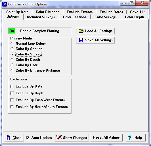
2. Color-By-Sections. When this option is selected, you can selectively color or exclude individual sections of the cave. The color-by-section options are controlled using the Color Sections page.
3. Color-By-Survey. When this option is selected, you can selectively color, label, mark or exclude individual surveys in the cave. You control the survey options using the Color Surveys page.
4. Color-By-Depth. When this option is selected, passages are colored according to their depth. You can control the color, spacing and width of each color band. The color-by-depth options are controlled using the Color Depth page.
5. Color-By-Date. When this option is selected, passages can be colored based on the date they were surveyed. You have complete control over the color of each range of dates and the width of each range. The color-by-date options are controlled by the Color By Date page.
Exclusion Options. The Exclusion options control which passages will be plotted or excluded from plotting. More than one exclusion option can be enabled so that passages can be displayed based on a combination of criteria. Here are detailed descriptions of the exclusion options:
1. Exclude-By-Date. This option allows you to exclude any survey that falls outside a certain range of dates. The exclude-by-date options are controlled by the Exclude By Date page.
2. Exclude-By-Depth. This option allows you to exclude any survey that falls outside a certain range of depths. The exclude-by-depth options are controlled by the Exclude Extents page.
3. Exclude-By-East/West-Extents. This option allows you to exclude any survey that falls outside a certain range of East and West positions. The exclude-by-east/west- extents options are controlled by the Exclude Extents page.
4. Exclude By North/South Extents. This option allows you to exclude any survey that falls outside a certain range of North and South positions The exclude-by-north/south-extents options are controlled by the Exclude Extents page.
Tilt Options. The Exclude-By-Depth and Color-By-Depth options can be adjusted so that they take into account tilt or inclination of the cave. Tilt options are controlled by Cave Tilt page
Loading/Saving All Settings. You have the option of saving all the Complex Settings so you can restore the display to its current state without going through the task of manually setting each individual option. To save the settings, go to the Options Page and press the "Save All Settings" button. Files are saved with the extension "ccml," but you can choose any name for the file and you can save as many different setting files as you want by choosing different names for the files.
The program currently saves 41 different parameters including the settings for each individual survey and section, the spacing and colors of all the Color Bars and every other important setting. The data is saved in such a way, that even if the underlying plot file changes, the previously saved settings can still be restored. For example, if the number of surveys increases or decrease or the order of the surveys changes, the program can sort out the differences and attach the attributes to the correct survey.The file format is XML, which means you can edit the file with a normal text editor or parse it with various XML parsing tools.
The settings can be restored by pressing the "Load All Settings" Button on the Options page. This will restore all settings, but it will not enable the display of Complex Options. This you must enable manually using the Enable Complex Plotting control described at the top of the page.
Normally, the set of complex settings can only apply to one cave or one plot file. For example, you wouldn't want to use the Complex settings for Carlsbad Cavern on Mammoth Cave because many of the parameters would be totally different. For example, the depth-bar settings would be entirely different because the caves have such different depths. For this reason, the program warns you if the Complex files came from a different cave than the one currently being displayed.
If you use this option with the option to save "Views" of the cave, you can setup unique images of the cave that combine all the complex features of the cave with specific views from certain angles and positions.