Trouble shooting. Here is are some common problems people may have with exporting KML files.
1. The Cave Data Will Not Export. The cave data must be geo-referenced or the Exporter will not be able to create a KML file from the data. Also, make sure the data has been resaved and recompiled with the latest version of the Program Manager. Old copies of the files will not work.
2. The Cave is Displayed in the Wrong Location. Make sure have the right location specified in the Project Manager. When in doubt, locate the entrance in Google Earth and use the coordinates Google Earth displays. Also, make sure the datum is set to the same datum used in the Project.
3. The Cave Is Under Other Overlays and Cannot Be Seen. It is often useful to apply another overlay to Google Earth like a topographic map. Because of the way Google Earth works, the cave passage may fall under the topographic map and be hidden. You can solve this problem using the "Ground Relative" altitude mode.
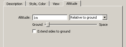
If you already have a file with this problem and you don't want to re-export it, you can also fix this problem directly in Google Earth. Start by selecting the cave passages that are hidden in the "Places" list on the left side of the Google Earth display Next, right click; this will bring up a menu. Choose the "Properties" options from the menu and go to the "Altitude" page. Change the option to "Relative to ground," and set the altitude to some small value like 1 meter. This will put the cave passage above the map overlay.
