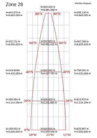
UTM Convergence. UTM coordinates work by mapping a square grid on the surface of the globe. Because of the fact that the globe is a curved surface, the lines of Longitude curve toward the edges of the UTM zone. The image to the right shows a typical UTM zone. The Grid lines are in gray and Longitude lines are in red. The line down the center is called the "Central Meridian and it does not curve. However, the further you move away from the Central Merian, the more the lines curve. As you can see from the drawing, the lines curve in such a way that they converge at the North Pole. This is where the word "Convergence" comes from. |
|
Convergence is the measure of the angle between the red longitude lines and the gray Grid lines. On the east side of the grid, the angle from the Longitude line to the Grid line is positive. Likewise, on the west side the angle is negative. Once you apply declination to a cave survey, the lines in the cave are aligned to True North. If you plot the cave survey on a map that uses UTM, the cave will not be aligned to the UTM grid and the location of the passages will be out of position relative to features on the map. |
|
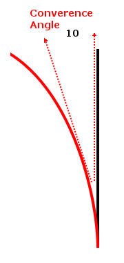
To solve this problem, you can apply the UTM Convergence angle to a cave survey. The example to the right shows how this is done. Again, convergence angle is measured from the red Longitude line to the black Grid line. Since the angle is clockwise, the value is positive. In this example, the convergence angle is +10 degrees. If you had a passage whose azimuth measured zero degrees, the passage would be aligned to the left-hand dotted red line. Since the dotted red line is counter clockwise from the black line, its angle is minus 10 degrees relative to the grid line. |
|
As a result, you always subtract the convergence angle from the azimuth.
The formula is thus:
GN = TV - Convergence. GN = Grid North Reading TV = True North Value. As another example, if the True North value was 5 degrees and the convergence was 10 degrees, the Grid North value would be -5 degrees: -5 = 5 - 10 |
|
Convergence Conventions. Convergence can be measured in two difference ways. These two methods are called 1) the Gauss-Bomford convention and 2) the Survey convention. Here is a description of each one.
1. Gauss-Bomford Convention. In this convention, the angle of the lines of longitude is subtracted from the grid lines. This means that in the Northern Hemisphere, positions to the East of the Central Meridian have positive convergence angles and positions west of the Meridian have negative angles. Positions in the Southern Hemisphere have the opposite signe.
This is the most commonly used method of deriving the Convergence angle. It is the method used in Compass and the Geographic Calculator returns convergence values calculated in this way.
2. Survey Convention. In this convention, the angle of the grid lines is subtracted from the lines of longitude. As a result, the Convergence angle has the opposite sign of the Gauss-Bomford convention. This method is only used in Australia and New Zealand.
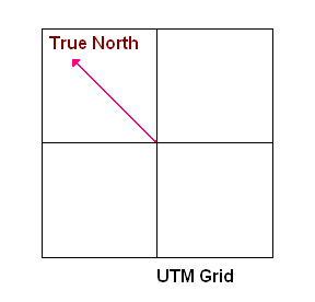
The feature should only be used when you are plotting on topo of maps whose coordinates are aligned to the UTM grid. On such a map, the a line dawn straight up the page will be aligned to UTM north, but not to the actual North Pole. This drawing helps illustrate the issue:
In the image to the right, the black lines show the grid for a map whose coordinates are aligned to the UTM Grid. The UTM grid is derived by projecting a flat, square grid onto a spherical earth. Since the earth's surface is curved, the direction to True North is also curved away from the vertical lines on the map.
If you are plotting your cave data on top of a map that is aligned to the UTM grid, a line drawn straight up the page will point to true north from the caves perspective, but to UTM north from the grid's perspective. The result will be that features in the cave will not correspond to features on you the UTM map. For this reason, it is useful to apply the convergence correction to the cave data.
Angle allows a cave map to be aligned to the UTM coordinates work by superimposing a grid on the surface of the earth. Because of the fact that the earth is a sphere, this grid will not be aligned to true north in some places. Since some maps may be aligned to UTM grid north instead of true north, Compass offers the option of aligning the cave to the UTM grid. The amount of misalignment from true north is called the “Convergence Angle.” This value is generally calculate by Compass if you are using UTM coordinates and kept in a Project File.
Remember, convergence is only useful if you want to plot the cave map on top of a map that is aligned to the UTM grid. Some topographic maps are aligned to true north, so in that case this option should not be used. |
|
Also, remember that if you are using Convergence, north will no longer be straight up the page. Likewise, the Compass north arrow option will point at UTM North, not true north.
For more information on these two conventions, check out this document:
http://www.iogp.org/pubs/373-21.pdf