Project Settings override all other types and kinds of settings in Compass. They are used to make sure a project is processed in the same on any computer. This is useful when you have different surveys with different settings. It is also useful when you are sharing your survey data with other people.
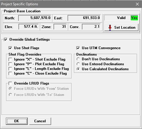
![]() To set or modify the Project Settings, you must select the Project Node in the Survey Tree. Next, press the "Set Project Options" button on the Tool Bar or select the "Project -> Set Project Options" item from the menu bar. This will display the "Project Specific Options' windows.
To set or modify the Project Settings, you must select the Project Node in the Survey Tree. Next, press the "Set Project Options" button on the Tool Bar or select the "Project -> Set Project Options" item from the menu bar. This will display the "Project Specific Options' windows.
Here is a description of each item:
1. Project Base Location. A Base Location is used to specify the general location of the cave or caves in a project. It is different from the Fixed Stations locations that are used to define the location of entrances, radio locations or other positions within a cave system. Fixed station locations generally have to be specified with an accuracy of less than a meter in order to avoid large closure errors between fixed points. Also, fixed locations can use a local coordinate system. For example, you could use the distance from landmark to specify entrance locations. Base Locations can only be used with Projects, not with individual data files.
The Base Location must be a geographic location specified in either Longitude/Latitude or UTM. It is generally used to calculate magnetic declinations for surveys. Since it refers to the cave or cave system as a whole, it does not need be precisely accurate.
Note: Compass does not save the date of the Base Location. As a result, the date will always revert back to the current date. The date is meaningless at the project level. The date is only meaningful at the survey level.
To clarify how all this works, here is a detailed description of how Compass uses a Base Location.
To calculate Declination, the program needs two things: 1) a date and 2) a location. The date has to be the date a specific survey was done. Since every survey in the cave can be done on a different date, a project-level date is useless; only the survey date matters. As a result, Compass uses the survey date for each survey to calculate the declination for that survey.
On the other hand, the location has to be a general location for cave, not tied to a specific survey or station. First, if the project doesn’t have fixed stations tied to geographic coordinates, it will be unable to calculate declination for the cave. Having a general cave location fixes the problem and allows the program to calculate declinations even if you don’t have an exact location for any stations. In fact, since declinations don’t change very much with distance, you can take the location from Google Earth or a topo map.
Second, even if there are fixed locations for stations in the cave, Compass may not know the locations of surveys until after it has processed and connected all the surveys together. That would mean that Compass might not be able to calculate the declination until after the cave is processed, which is too late. Having a global cave location, allows Compass to calculate the declination of every shot as soon as it is processed.
Setting The Base Location. The current Base Location is specified at the top of the window. Press the "Set Location" button to set or change the Base Location. This will display the Geographic Calculator/Editor. You simply enter the Longitude, Latitude or UTM coordinates of the cave system.
2. Override Global Settings. The Project Manager has about a dozen setting that control the processing of cave data. You can preset these values and save them as defaults that appear every time you use Compass. However, these settings may not be right for every survey project. They also may not be right when you exchange data with other surveyors. For this reason, Compass allows you put some settings in Project File. These settings that will take precedence and override the default settings. In this way, the data will be handled the same way, no matter what computer they are processed on. Here are the options.
Enabling Overrides. To override the default settings, enable the "Override Global Settings" check box. You can then set the values you wish to override. When you are done making the changes, be sure to click the "OK" button and save the project. Here is a description of all the options you can override:
A. Use Shot Flags. This option enables the use of Shot Flags. It takes precedence over the same option in the default settings. When the option is enabled, Compass applies the shot flags that are found in each shot. If the option is disabled, Compass ignores the shot flags.
B. Shot Flag Overrides. Compass has a set of flags for each shot in a survey that allows you to control how an individual shot is processed. This optionallows you to disable the use of any of the flags for all the surveys in a project. It takes precedence over the same options in the default settings. Note: it also includes the Close flag.
C. Override LRUD Flags. Compass allows the LRUDs to be associated with either the From or To station of a shot. This option is normally set in the Survey Editor's header section. Compass has a default setting in the Project Manager that allows you to override the survey-level settings. This particular setting is a third option that overrides both the survey level and default level settings. When enabled, this option take precedence over all other options.
D. Use UTM Convergence. This option enables or disables UTM Convergence for all the data in the project. It takes precedence over the same option in the default settings.
E. Declinations. This option controls the way Declination is derived and applied for all the data in the project. It takes precedence over the same option in the default settings.