The Pos/Scale Tab allows you to scale, Rotate and position the cave in Map Display any way you want. Since the Map Display map is also the map that is used for SVG Export and the Merge/Morph process, it also controls those aspects of the program.
View Control. This option controls whether the cave is displayed in Plan View (from above) or in Profile Mode (from the side). As the View Mode is changed the Map Display will change to reflect the new view angle.
Units Control. This option controls the units that will be used throughout the SVG Exporter. Selecting "Feet" will display the cave position and map coordinates in Feet and paper coordinates in Inches. Selecting "Meters" will display the cave position and map coordinates in Meters and paper coordinates in Millimeters
Scaling. The scaling options allow you to set the scale of the cave in the SVG file. The scale can be set in Feet/Inch or Meter/cm, depending on the units that you have chosen. |
|
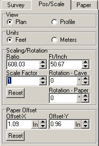
The scaling can also be set as Scaling Factor, which multiplies the base scale by any number. Finally, you can set the scale to a ratio value such as 1:1000. Al the different scaling values are synchronized so changing one value will change the others proportionally..
Rotation. This option rotates the cave around its center. The values is specified in degrees. There are two versions of the rotation, one shows the clockwise rotation of the cave; the other shows the clockwise rotation of the paper relative to the cave. Each one is useful in certain situations.
Paper Position. This option sets the position of the first station in the cave to a place on the paper. The first station in the cave is usually the entrance. When you first load a plot file, the program automatically calculates a position for the first station that centers the cave on the paper. You can move the cave's position on the paper by adjust the controls. The "X-Offset" control moves the cave left and right and the "Y-Offset" controls move the cave up and down.
The Paper Position control is used in conjunction with the Station Tie-In option to place a specific station at specific place on the paper. This allows cave passages to be place in the same location on the paper even if the cave grows or passages re-mapped.