he SVG Tabs control aspects of the exported map. Here is a description of each item:
A. Grid. The exported SVG map contains a grid of lines in the background that mark distances. There are heaving and light lines in the grid. The heavy lines are placed a certain distance apart that corresponds to the "Spacing" value" displayed in the "Spacing" box shown to the right. The light grid lines are 1/5 the spacing of the heavy lines. So for example, if the heavy lines are 100 feet apart, the light lines will be 20 feet. B. Scale Bar Type. The exported map also contains a scale bar. The scale bar can be one of two types. i. Module-5 Length. The "Modulo-5 Length" type sets the scale bar length to even multiples of five. For example, the scale bar might be drawn so its length 5, 10, 15 or 20 meters or feet. |
|
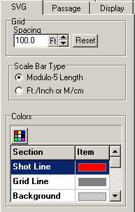
ii. Ft/Inch or M/cm. In this mode, the scale bar follows the scale setting for the map. If the scale were 59.7 feet per inch, the scale bar would be 1 inch long and that one inch would represent 59.7 feet.This is useful when the actual scale is not a round number. For example, if the scale of the map were 97.5 feet per inch, the scale bar would be a length of 100 feet, which would be slightly less than an inch long. C. Colors. This option controls the colors of various exported aspects of the map. You can control the color of the Shot Line, Grid Lines, Background, Passage Walls, Passage Fill, Floor Color, From LRUDs, To LRUDS, Station Labels, Station Markers and Frame around the border of the map. |