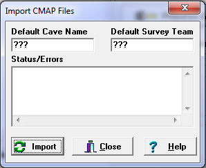
To import an CMAP file, select “Tools|Import CMAP File” from the menu bar. This will display the CMAP Import Window.
Default Cave Name. CMAP files do not carry a cave name. For this reason, the import tool allows you to enter a cave name. Simply type the cave name you want to use into the edit box.
Default Survey Team. CMAP files do not carry a survey team information. For this reason, the import tool allows you to enter the names of the people who made up the survey team. |
|
Importing Data. To import data, press the "Import" button and select an CMAP file to import. As the conversion process proceeds, status information and error messages will be displayed. Finally, when the conversion process is complete, press the "Close Button." To view the newly converted data, select the "File|Open Project/Data File" option from the menu bar.
Import Issues. Because of incompatibilities between programs, newly imported data may require some editing and reorganization before it will view properly. Here are some of the issues you may encounter:
1. Surveys. CMAP does not divide the data into individual survey like Compass does. The only hint that CMAP gives that there is a new survey, is a change in declination. If the program does not find a new declination, it will create a new survey every 250 shots. Since these divisions are arbitrary, you may want to restructure the surveys to match the real surveys division.
2. Survey Names. CMAP also does not have survey names. For this reason, the program analyzes the shot data and make a guess at the survey name. You may need to choose a more appropriate survey name.
3. Comments. CMAP allows free-form comments scattered through out the data. Compass, put the comments in specific places that correspond with the survey heading and each individual shot. For this reason, the program spreads the CMAP comments throughout the Compass shots. You may need to move the comments to more appropriate locations.
4. Survey Team. The program allows you to enter a default survey team. However, since the team is likely to change from survey to survey you will probably have change or manual enter most of the team information.
