Compass includes tool import PocketTopo exported Text files. Compass will not import PocketTopo ".top" files because the format of these files is not documented. As a result, you have to use the PocketTopo export option and save the information as text.
To import Pocket Topo files, “Tools->Import PocketTopo File” from the menu bar. This will display the PocketTopo Import Window.
Default Survey Team. PocketTopo files do not carry a survey team information. For this reason, the import tool allows you to enter the names of the people who made up the survey team.
Default Zone. PocketTopo files do not carry UTM zone information for fixed stations. For this reason, the import tool allows you to enter a default UTM Zone that will be applied to any fixed stations the survey data might have.
Exclude Splays From Length. Enabling this option causes the importer to mark each splay shot the "L" flag which excludes the shot-length from the total cave length. . |
|
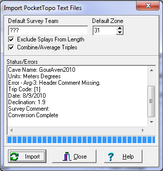
\Combine Triples. Pocket Topo allows you to enter three measurements for the same shot as a way to insure an accurate measurement. If the "Combine Triples" option is enabled, the three shots are combined into one shot and each measurement is averaged. If the option is not enabled, each triple will be left intact and you will have groups of three shots of the same two stations.
Importing Data. To import data, press the "Import" button and select an PocketTopo file to import. PocketTopo files usually have the extension ".txt." As the conversion process proceeds, status information and error messages will be displayed. Finally, when the conversion process is complete, press the "Close Button." To view the newly converted data, select the "File|Open Project/Data File" option from the menu bar
Import Issues. Because of incompatibilities between programs, newly imported data may require some editing and reorganization before it will view properly. Here are some of the issues you may encounter:
1. Documentation. The PocketTopo file format is not well documented so I had to work out some of the details experimentally. This means that the program might not convert every file perfectly. If you run into a problem, please contact me through the contact form on the Compass web page so we can make arraignments to get a copy of the file so I can fix any problems.
2. Survey Team. The program allows you to enter a default survey team. However, since the team is likely to change from survey to survey you will probably have change or manual enter most of the team information.