This option allows you to control how the Quad grid is connected to the cave. The quad grid always connects to the first station in the cave, which is generally the entrance. Even though the grid only connects to the first station, it can be moved to any position over the cave.
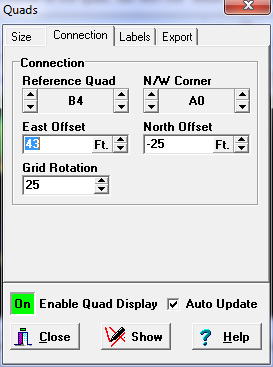
1. Reference Quad. This option controls which cell is connected to the first station. The station is connected to Northwest corner of the quad, but with the "offset" described below, it can be moved to any location. The "arrow buttons" allow you to select the row and column label for the correct quad.
2. N/W Corner Quad. This option sets the label for the quad in the Northwest corner of the grid. This is the starting point for the grid, so it controls how the whole grid is labeled. You can use it to create grids that are subsets of larger grids. It is also useful for creating reverse numbered grids. When you make changes to this option, Reference Quad options automatically changes so you don't have to reset the connection.
3. East/North Offset. These values are used to shift the grid to the East and North. This allows you to move the grid to any position over the cave. For example, if you set the East Offset to 100 feet, the grid will be shifted 100 feet to the east.
4. Grid Rotation. Usually, quad maps are aligned along north-south, east-west lines. However, sometimes it is useful to align the grid so it matches the alignment of the caves. This option allows the grid to be rotated so it can be align with the cave or any other feature. |
|