Compass can also display additional information about each shot or station in the cave. The information includes the Azimuth, Length, Inclination of shots; and the Entrance Distance, and Station Coordinates of Stations.
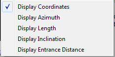
You can display this information by selecting the “Display->Label/Mark” option from the menu bar and then choosing “Display Azimuth”, “Display Length”, “Display Inclination”, "Display Coordinates," or "Display Entrance Distance."
Shot information is placed at the center of the shot. Length can be display in either Meters or Feet depending on how you have setup the Viewer.
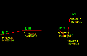
1. Coordinates. This option displays the coordinates of each station in the cave. If the cave has been geo-referenced a station's coordinates will be the actual world coordinate of the station. (For more information about geo-referencing a cave, refer to the Compass Project Manager Help file.) The coordinates can be displayed in three different units UTM, Longitude/Latitude in degrees, and Longitude/Latitude in degrees, minutes and seconds. UTM can be displayed in either feet or meters, although meters is the standard unit for UTM. Coordinate options can be set in the Settings Dialog. Note: if the cave is not geo-referenced, displaying Longitude/Latitude will produce meaningless numbers.
2. Azimuth, Length, Inclination. These are the original shot measurements used to survey the cave. The measurement will match exactly what is displayed on the screen but not necessarily the original shots entered in the survey editor. This is because Compass closes loops and performs other adjustments that may change the values. Also, shot directions may be reversed because the Compass Compiler may optimize the station/shot order.
3. Entrance Distance. This is the distance from the entrance of the cave to the specific station. This is not the straight line distance. It is the distance traveled through the passages. When more than one route is available to the entrance, the distance is measured along the surveys that appear in the data first. This means that other routes may be shorter or longer the number displayed. The distance can be display in either Meters or Feet depending on how you have setup the Viewer.
Station Information. The station information items allow you display additional information about each station in the cave. Station information is placed immediately below the Station, leaving enough room for the Depth and Station name in case they are enabled. Here is a more detailed description of each option: