The Main Image shows a picture of the current image being morphed. If you have loaded a plot file, the shot lines and will be superimposed on top.
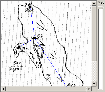
The purpose of the display is to compare the differences between the cave survey data and the sketch-map. This allows you to locate and specify where the errors in the sketch map are.
To do this, you scale and position the cave survey data so the survey stations are close the correct position. When you have done this, some of the stations in the survey data will not match the sketch-map. This is a clear indication of errors in the sketch-map. You tell the program where the errors are by moving the stations in the survey to the corresponding location on the image. This tells the program where the errors are so it can warp that part of the sketch back to its proper place. |
|
The individual stations can only be moved when the "Show Handles" option is enabled. When the handles are enabled, square blocks called "handles" are show at each survey station. Clicking on a handle and dragging cause the handle and survey station to move. This allows you to move the stations to their locations in the sketch-map. Note: when the handles are enabled, the plot as-a-whole cannot be moved. To reposition the whole plots, disable the handles. |
|
The image can also be magnified so you can see more detail using the Magnifying Bar. This is useful for precisely moving the handles and stations. |
|