|
|
|
Topo-Grabber - Free USGS Topographic Maps
|
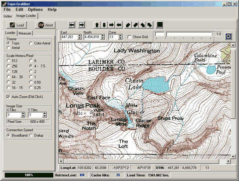
| Topo-Grabber
is a program that allows you to download USGS Topographic maps
of the United States, including the lower 48-states, Alaska and
Hawaii. These maps are full-resolution USGS topographic maps
that are exactly the same as the paper maps you would
buy from the government. |
|
|
All maps are completely free of cost. You can also download high resolution Black and
White aerial photographs of the entire Unites States with
resolutions down to 1 meter/pixels. Full color aerial photographs
with resolutions down 1/4 meter/pixel are available for certain areas in and
around some large towns and major cities. |
 |
|
Update and Good News: Although Microsoft announced in 2012
that it was discontinuing their Map Server that Topo-Grabber
used to get its topo maps, so many people complained that
they relented. As of June, 2014, the server is working as well as
ever and might even more responsive than before. I have noticed
occasional service outages and at times, the server is slow, but
it is usually responsive in if you wait a half hour.
Since the service continues to be available, the
program has been upgraded with several new features. For
example, the program loads the topo maps faster and uses less
system resources. There is also the option to display 7.5, 15,
30 minute and 1 degree grids lines. |
|
Features |
| 1. Simple Mouse Zoom and Positioning.
The program allows you to drag the map into position by dragging
it with the mouse. You can center and zoom on a location in the
map by double clicking. |
| 2. Resolution.
There are a total of 12 different resolutions. These include
the standard USGS resolutions that correspond to 30-minute,
15-minute and 7.5 minute quadrangles. There are also
intermediate resolutions plus super high resolutions down to as
little as 1/4 meters per pixel for some aerial photographs.
3. Map Size. The maps can be any size
ranging from a 0.25 x 0.25 mile patch to maps covering hundreds
of miles. Maps can also be zoomed and magnified to focus on
specific areas or to make it easier to see more detail. |
 |
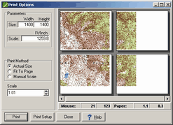
| 4. Printing.
The maps can be printed on any color printer. The prints can be
single sheets or multi-sheet allowing very large maps to be
pieced together. You can print very large maps and create
seamless maps that covering an area much larger than a typical
paper map. A "print-preview" option allows you to see
exactly how your maps will look, even if they are spread over
dozens of sheet of paper. |
 |
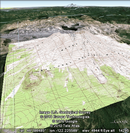 |
| 5. Google Earth
Overlays. The Topographic maps can be exported as Google
Earth KMZ files to be overlain on the Google Earth Globe. This
can be very useful because Google Earth doesn't always have all
the terrain details, surface features and place names that a
USGS topographic maps does. |
|
 |
 |
| 6. Move To Google Earth
Location. If you find a location in your map that you want
to examine in more detail, you can press a button and Topo
Grabber will automatically open Google Earth and zoom on the
same location you are viewing in the topographic map. |
 |
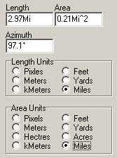 |
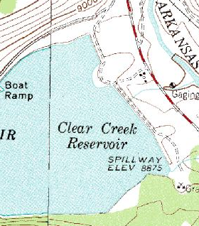
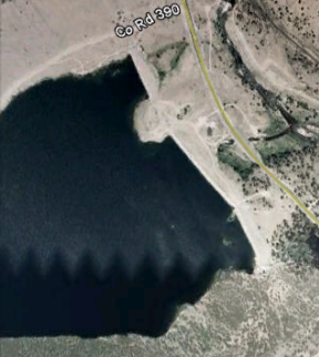
| 7. Measurement Tools. You
can measure distances, angles and area on topographic maps and
aerial photos. For example, in the image above, we have measure
the perimeter and area of small reservoir in Denver Colorado.
The distance around the lake is 2.9 miles and the area 0.21
square miles. You have choice of units including Acres, Feet,
Meters and Miles. |
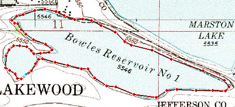
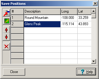
| 8. Saved Positions. You
can save map locations for later recall. Each saved position
retains the location, map resolution and the type of map. This
makes it easy to recall locations and maps that would ordinarily
takes several minutes to find. The image
to the right illustrates the operation of the Save Positions
feature. It shows two saved positions, one in Montana and the
other in New Mexico. To retrieve the save position, you just
double click on the item. |
|
|
|
User License |
| The program is free of charge and
does not contain any advertising or limitations. You are free to
use it however you see fit. However, you may not repackage or
sell the program. |
|
|
|
|