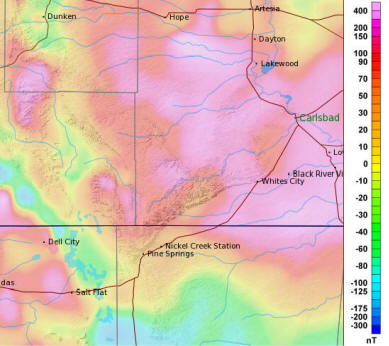
| Correcting Magnetic Anomalies.
It is possible to correct magnetic anomalies. John
Halleck has written extensively about the techniques.
[3,4]
As John points
out, these techniques are widely known to Land Surveyors
and cavers could use them in caves with magnetic
anomalies. I wrote this document to give a simple
description of the concepts and step-by-step procedures
to use the technique.
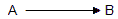
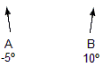
The First Station Anomaly. To illustrate the
concepts, we'll use a simplified cave that is a series
of shots going due East. Here is what the first shot
looks like:
I'm assuming that Station-A is at the
entrance and has access to the outside world. The first
step is to find the magnetic anomaly at this station.
To do this we need to use an external reference point
that isn't affected by the Earth's magnetic field. This
could be stars, the sun or nearby landmarks. But the easiest way to calculate the
anomaly is with a GPS receiver.
To begin, find the location of
Station-A with a GPS receiver, then find another
location about 50 feet away from Station-A that is due
East, West, North or South of Station-A. In this
example, I've chosen a location that is due North of
Station-A. Mark the location with a cairn or have a
person stand on the location. Now do a compass shot to
the location. The difference between the actual azimuth
and measured azimuth will be the magnetic distortion at
Station-A.
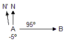
In this illustration, I've chosen a location that is
due North of station-A. N
shows the direction to True Magnetic North and N' shows
the direction the compass actually points. As you can
see, the compass direction is 5 degrees west of where it
should be. When you sight your marked
location, the compass needle will be pointing 5 degrees
west of North, so your marker will appear to be at
azimuth +5
degrees. To calculate the magnetic anomaly, you would subtract the
apparent azimuth of your Marker from the actual
azimuth:
A = Actual Azimuth To Marker
B = Measured Azimuth To Marker
D = Magnetic Anomaly
M
= A - B
-5 = 0 - 5
Now that we have the magnetic distortion for
Station-A, we can proceed into the cave.
Station-A will have the same magnetic distortion no
matter what way we face. When we turn to take a shot for
Station-A to Station-B, that shot will have the same
magnetic distortion that we already calculated. That means
we can eliminate the distortion on shot A-B by adding
back the calculated error.
In this case, the compass needle for
shot A-B will be pointing 5 degrees counterclockwise so
the shot azimuth will be 5 degrees bigger than it should be.
In other words, the shot will read 95 degrees instead of
90. To fix the distortion, we add the -5 degree magnetic
distortion to the 95 degree angle to get a correct
azimuth of 90 degrees.
Anomalies In the Cave. Once we move fully
underground, we can no longer use GPS to find and
correct anomalies, so we have to use a different
technique. The key to doing this is the fact that we
have corrected shot A-B and we can now use it as a
reference to find the anomaly at Station-B. Since
magnetic anomalies change over relatively short
distances, we can expect that every station in the cave
will have a different magnetic anomaly.
For this example, I'm going to say that Station-B has a distortion
of +10 degrees East. That means
Magnetic North points in a different direction at
Station-B than Station-A.
The way to find the distortion at
Station-B is to do a backsight from B to A. Since the
foresight from A to B has been corrected, any difference between the
foresight and the backsight will be caused by the
magnetic anomaly at Station-B. For example, if you did a backsight from
Station-B to Station-A, you would expect the azimuth to
be 270 degrees, the reverse of a 90-degree foresight.
But because of the magnetic anomaly at Station-B, the angle between North
and the shot has changed and now the backsight is 260
degrees.
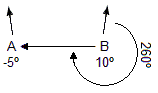
If the measurements have been done
carefully, the 10 degree difference between the
foresight and the backsight will be caused entirely by
the magnetic anomaly. In other words, we've measured
the exact magnetic anomaly at Station-B from the
difference between the foresight and backsight values.
The magnetic anomaly at Station-B is
the same for any shot starting at B. For example, if the
next shot is between B and C, the azimuth for that
shot will be off by 10 degrees. In the example below,
instead of 90 degrees, the shot will measure 80 degrees.
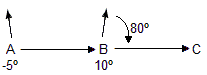
But, since we now know the error, we
can add 10 degrees and correct it to the proper value of
90 degrees. This process can be continued for
every shot in the cave. For example, now that we've corrected the
anomaly in B-C, we can find the anomaly at Station-C.
Once again, we do this by taking a backsight from C to
B.
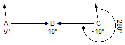
This time the magnetic field has
shifted 10 degrees to the West, so the backsight will
measure 280 degrees instead of 270. If you subtract the
backsight from the reversed foresight, you get a -10 degree
anomaly for Station-C. Since we now know the size of the
anomaly at Station-C, we can now correct the next
foresight.
Step-By-Step Procedures. To
simplify things here is a set of procedures to correct
for magnetic anomalies in a cave survey:
I. Find The Anomaly At The
Entrance Station. The first task is to find the
magnetic anomaly at the entrance station. There are
three steps:
A. Place A Marker At A Known
Bearing. Using a GPS receiver, find a location
50 feet from the Entrance Station that is either due
North, South, East or West. Mark the location with a
cairn or have a person stand on the location. The
main thing is to have a location that is easily
visible from the entrance station.
The 50-foot distance isn't
critical, it could be 25 or even 10, but longer
distances will be slightly more accurate. Likewise,
the direction isn't critical, as long as you know
the actual compass bearing to the marker. Never the
less, it is easier and involves simpler math if you
choose a location that is in a cardinal direction.
In cases where the Entrance
Station is not visible to the outside world, you can
choose a different location a few feet away. Just
remember that magnetic anomalies can vary over short
distances, so try to keep it as close to the
entrance station as possible. In the worst case
scenario, you may need to add another shot from the
entrance station to the outside world.
If you don't have a GPS receiver,
you can also use landmarks that are shown on
topographic maps or even the stars. However,
this is much more complicated and requires extra
calculations to find the actual bearing.
B. Measure the Bearing to the
Marker. Now take a shot with your compass from
the Entrance-Station to your marker. Do the best job
you can
measuring this angle because any errors will affect
the whole survey. Do not do a backsight on this
shot. The magnetic anomaly at the Marker will
be different from the one at the Entrance. We only care
about the anomaly at the Entrance.
Important:
It is important to remember that magnetic compass
readings also contain declination errors. If you are
using Compass to survey a cave, the declination
errors would normally be handled by Compass when you
enter the survey data. However, in this case, we
need to know the distortion relative to true north,
not magnetic north. For this reason,
you must adjust the
Bearing using the Magnetic Declination to convert the
compass reading to True North. You do
this by adding the Magnetic Declination for your location.
You can get the Declination for a particular place
and date from the Compass Geographic Calculator that
is available in the Project Manager under the
"Tools" menu. For example, if the Bearing was -5
degrees and the Magnetic Declination was +10
degrees, the True-North bearing would be +5 degrees.
In addition, when you enter this survey data into
Compass, you should set the declination value for
the survey to zero.
C. Calculate The Distortion.
You can now calculate the magnetic anomaly at
the entrance station. You just subtract the
measured bearing from the actual bearing.
A = Actual Direction To Marker
B = Bearing To Marker
D = Magnetic Anomaly
M
= A - B
II. Adjust the Next Shot In the
Cave. Since we now have the anomaly for what is now
the From station of the next shot, we can adjust the
foresight for the next shot in the cave. You do this by
adding the anomaly value to the azimuth value for this shot.
You only adjust the foresight measurement. Once you do
this, the foresight shot will be considered free of
magnetic distortions and we will use it for the next
step.
III. Calculate The Anomaly for the
Next Station. To calculate the anomaly for the next
station, we compare the foresight and the backsight of
this shot. Since the foresight is now distortion free,
only the backsight will contain the magnetic anomalies.
Since the backsight is taken from the "To" station, the
anomaly value applies to the To station.
Since the backsight runs in the
opposite direction as the foresight, the first step is
to reverse the backsight by adding or subtracting 180
degrees. Next, you subtract the backsight value from the
foresight. This will give you the anomaly value.
A = Magnetic Anomaly
F = Foresight Azimuth
B = Backsight Azimuth
A = F - B
IV. Repeat. You now repeat
Steps II through IV until all the shots in the cave have
been processed.
If you are interested in more detailed
and technical information about handling magnetic
anomalies in caves, refer to the footnotes listed below: |