Issues of
Using Radio Locations To Specify The Location of Survey Stations
I periodically get questions about using radio locations to set
the position of survey stations within a cave. Here are some
ideas that were generated during a discussion on the Compass
Users' Group:Cave Radio. Low frequency radio signals
can penetrate the earth for several hundred feet and this makes
it possible to communicate between people working the surface
and people inside a cave. The low frequencies involved require
that the signal be transmitted and received using coils of wire
instead of ordinary antennas.
It is possible to use a cave radio to measure the GPS
position of stations in the cave. You just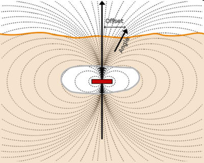 move the receiving coil around above ground until you find the
location of the maximum signal. In theory, this point should be
right above the transmitting coil. Once you've located the point
of maximum signal strength, you can take a GPS reading to know
the East and North position of the cave location in Geographic
Coordinates.
move the receiving coil around above ground until you find the
location of the maximum signal. In theory, this point should be
right above the transmitting coil. Once you've located the point
of maximum signal strength, you can take a GPS reading to know
the East and North position of the cave location in Geographic
Coordinates.
You can also measure the depth of the station, by moving a
short distance from the location and measuring the angle of
magnetic fields. You can then use Trigonometery to calculate the
depth. Here are some links the give more details on the process:
1)
Radio Location - An Introductions. 2)
Radio
Location in Caves
Radio Location Accuracy. Many people assume that
since you detect a cave location by transmitting a signal
directly to the surface, the measurements must be accurate.
Depending on circumstances, these measurements may not be any
more accurate than compass-and-tape surveys.
Depth Measurements. Because measuring depth requires
measuring the angle of the magnetic field, it is widely
understood that depth measurements with cave radios is not very
accurate. This is especially true with deeper caves because the
deeper the signal source, the more effect small errors can have.
X-Y Measurements. As I pointed above, most people
assume that the X-Y or East-North aspect of a radio location
will be more accurate than the depth measurement. However,
similar problems apply to X,Y aspect of a radio location. There
are several sources of error for the X/Y aspect of Radio
locations:
1. Coil Leveling. In order for the X,Y aspect to be
accurate, the transmitting coil must be absolutely horizontal
(level) and the surface receiving antenna absolutely vertical
(orthogonal). Most cave
radios use a Spirit Level to make the coils horizontal.
Depending on the curve of the glass in the Spirit Level, the
accuracy can be as little as 2 degrees per millimeter of bubble
displacement. (Here is some information on
Spirit Level Sensitivity.)
In addition, the spirit level must be attached to the coil so
it is at a perfect right angle to the plane of the coil. Cave
radios are generally home-made devices and so they lack the
precision of a factory-made product. Even if they were
factory-made, that wouldn't guarantee any higher accuracy than
the typical instruments we use for regular surveying. For
example, even a precision-made product like a Suunto
Inclinometer only has a resolution of 1 Degree. That means it
very unlikely that a cave radio could leveled more precisely
than 2 degrees. A 2-degree error in level would produce position
errors of 16 feet at 500 feet of depth.
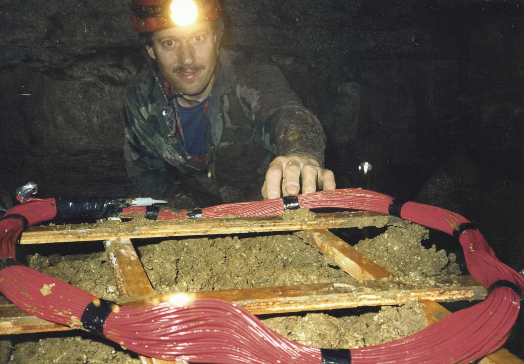
Take a look at the image at this link:
Image Of Cave Radio Coil. As you can see, it would be
difficult to accurately level a transmitter coil like this.
Finally, just like other cave instruments, spirit levels are
subject to the same type of reading errors that compasses and
inclinometers are, especially in the harsh cave environment.
Judging by the number of blunders I see in ordinary cave survey
measurement, it wouldn't be surprised if you had large numbers
of leveling error attributable to human error.
2. Coil Manufacture. Even if the coils are perfectly
horizontal, distortions in the magnetic field can be produced by
the way the coils are manufactured. The coil itself should be
symmetrical and as flat as possible, without any folds or bumps,
or the field may be distorted. Again, home-made coils are not
likely to be flat, especially if the coils are made to fold for
easy transport through the cave.
3. Rock Characteristics. In addition, the rock above and
around the cave may affect the magnetic field. Most limestone
deposits have pyrite and limonite deposits that can distort the
magnetic field. This is particularly true around joints and
faults were caves are concentrated and ground water has the most
chance to redeposit minerals. Finally, changes in the saturation
of ground water can affect the magnet field. As an example of
this type of phenomena, there are large magnetic distortions in
the magnetic field in Lechuguilla cave near the "Rift" area. I
also have an aviation map that warns of large magnetic compass
deflection near Manitou Springs, Colorado, which is one of our
favorite caving areas.
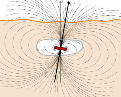
This is what Ian Drummond said about the magnet field
distortions:
"Unfortunately the effect of the conductive ground is not
just to weaken the intensity of the magnetic field, but also to
induce a component which is out of phase. As a result the
magnetic field on the surface above the cave is no longer
plane-polarized, but rotating."
http://caves.org/section/commelect/drupal/files/Speleonics/splncs07.pdf
If the magnetic field is no longer "plane-polarized" then peak
position of the radio signal is likely to be offset from the
actual underground position of the transmitter.
How To Enter Cave Radio Locations In Compass. In many
ways, radio locations are subject to the same types of errors
that ordinary shots are subject to. For this reason, it is best
to enter them like survey shots. That means that you shouldn't
enter a fixed station with the X,Y taken from the GPS and the Z
derived by subtracting the depth.
What you should do is enter a fixed GPS location for the place
on the surface where the radio location was taken. Then you add
an artificial vertical shot with an inclination of -90 and a
length equal to the radio depth measurement. Compass would then
treat it as an ordinary survey shot with the same error
processing as a regular shot.
GPS Accuracy. Most people assume that GPS receivers
are highly accurate, but even they have their own source of
errors. For example, non-"survey grade" GPS receivers can have
errors as much as 10 meters or 30 feet. Vertical errors can be
has much as 20 meters or 60 feet. (Thanks to Paul Jorgenson
these numbers.)
Here is a summary of the types of errors with radio
locations:
http://www.chaos.org.uk/survex/cp/CP10/CPoint10.htm
|

