The COMPASS Project Manager
The Project Manager is the master control system for all COMPASS operations.
It automates all aspects of the surveying process. Here is snapshot of the
Project Manager window:
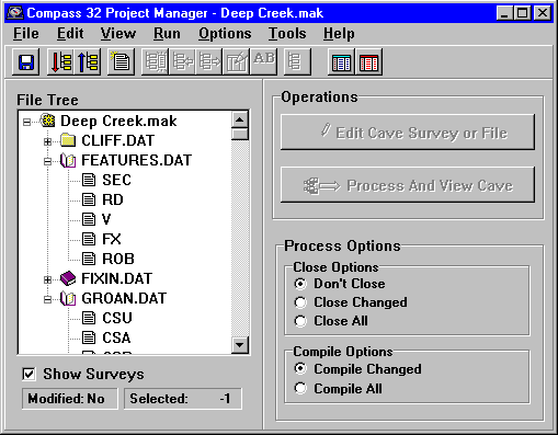
On the left you can see the "project tree." The project tree shows all the
parts of the project. Survey projects are based on "master" files which organize
the various parts of the cave data. As you can see, the name of the master
file (Deep Creak.mak) is displayed at the top of the tree. The individual
survey files (Surface Line.DAT, FEATURES.DAT, FIXIN.DAT GROAN.DAT) appear
below the master file. Finally, the individaul surveys (SEC, RD, V, etc.)
appear below the survey file name.
This particular project combines several different files related to Groaning
Cave. The survey Surface Line.DAT, contains a survey line along the cliff
face, FEATURES.DAT contains surface features like roads, and section lines.
Finally, GROAN.DAT and FIXIN.DAT contain the actual survey data for Groaning
and Fixin Cave. This particular project file combines the cave and the surface
features into a single image.
One of the special features of COMPASS is the ability to use the same survey
file in several different projects. For example, you could create another
project file that also used GROAN.DAT and combined it with a different set
of files. For instance, you could create a combined image of Groaning and
other nearby caves.
Once you have organized your data, processing and displaying the cave is
just a matter of clicking on the "Process And View Cave" button on the right
side of the window. By clicking on various parts of the "project tree" you
can control which parts of the cave are displayed.
The radio buttons in the lower right control how the data is processed. You
have complete control over closing and compiling the data. The Project Manager
even keeps track of the dates and automatically re-processes the files that
have changed.
|