COMPASS Editor
The survey editor is one of the most important parts of a cave surveying
package. A large cave system can have as many 30,000 shots and each
one has to be entered by hand. This process can be very tedious and it is
one of biggest sources of survey errors. For this reason, the COMPASS
editor was specially designed to detect and eliminate errors as the data
is entered.
Some editors take a "free form" approach to entering data. This means
any kind of data can be typed into any cell. For this reason, the editor
does not know what each item of data is until it is processed. This means
the program cannot do any error checking until the data is processed. It
also means that the program cannot prompt the user for what data should be
typed into each cell. This makes it harder for novice users to enter data.
The COMPASS editor has a cell for each data item, so it knows what
should be into each cell. This means that the program can check each item
as it is entered. It also means that the program can guide the user by telling
her or him exactly what the data item is and how it should be entered.
COMPASS does all of this and still allows you to configure the layout
of the screen so that it matches your survey book. You have complete control
over the units, data order and format.
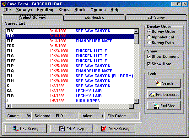
The COMPASS Editor consists of three "pages". By clicking on the tabs
along top, you can select the Survey Selection Page, the Heading
Editor and the Shot Editor.
Survey Selection Page.
COMPASS stores multiple surveys in each survey file. The Selection
Page allows you to find and select individual surveys for editing or
other operations.

The Survey List shows a list of all the surveys in a particular survey file.
The first column shows survey name or survey prefix. This is usually the
alphabetic part of a station name. For example, the "AB" survey would probably
have station names like AB1, AB2, AB3 etc. The next column shows the survey
date. The final column shows the survey comment. The survey comment is used
to give a more detailed descriptions of the survey.
Surveys can be displayed in the order they were entered, in alphabetical
order or sorted by surveyd ate. Many operation can be performed at a survey
level. You can search for a particular survey in the list. You can use
"wild-card" characters to match partial survey names. You can search for
individual shots and stations within all the survey. These searches too support
"wild-cards." Another powerful feature is the ability to modify blocks of
surveys all at once. For example you can replace or selectively replace part
or all of the cave name, survey comment, or survey team. You can prefix,
postfix, replace or selectively replace survey names. You can set dates,
declinations and correction factors for large blocks of surveys. The units
for length, compass and inclination can be set. Finally, the shot flags can
be set for large groups of surveys.
The Heading Page
Each survey in COMPASS is required to have a "Heading." The Heading contains
information like the name of the cave, name of the survey, survey description,
survey date, the names of the survey teams, declination and correction
factors. The Heading Page allows you to enter this information.

Here you can see most of the heading page. The top of page shows the heading
information. The correction factors are scrolled off the bottom of the list.
The bottom of the page shows the units that are being used, the order the
data is presented and whether backsights are enabled. A survey calendar
is available that displays the survey date in calendar format. This makes
it easy to see the day of the week and well as the date of the survey. Since
many surveys are done during the weekend or on holidays, this makes it easy
to reconstruct expeditions and dates.
Shot Editor.
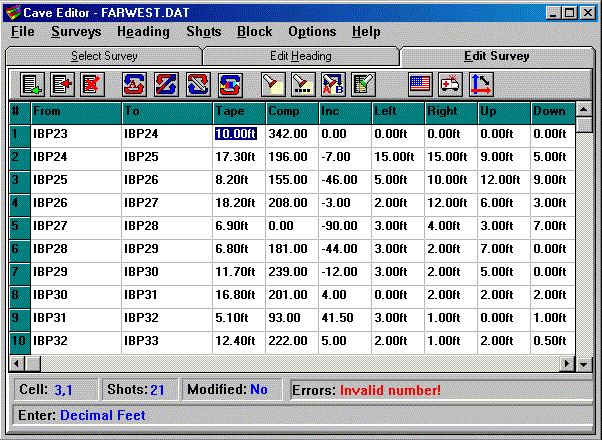
The Shot Editor is the place where the actual shots are entered. Each cell
corresponds to a particular data item such station names, compass measurements,
shot length inclination and passage dimensions.

Scrolled off the right hand side of the display are cells for the shot flags
and shot comment. As you move from cell to cell entering data, the bottom
line of the window prompts you the kind of information you should enter.
If you make a data entry error that program can catch, the Editor makes a
sound and displays an error message. On this screen you can see that someone
has tried to enter an invalid number.
Simple data-entry errors, like reversing the station order or reversing
shots can be corrected with a click of the mouse. If you enter the wrong
data into a cell, hitting Escape restores it to the original value. More
complex errors can be repaired across the whole survey. For example, you
can fix data that was entered in the wrong units, in the wrong order or in
the wrong cell. You can even apply a formula to any data item.
Everything on this screen is configurable, including units, shot order, fonts,
cell size, and screen colors. This makes it easy to configure the editor
for large monitors and higher resolutions. For example, using a smaller font
on larger monitor will allow more information and more shots to appear on
the screen.
Other features include searching, replacing and global modifying of all survey
items. Data can be copied to and from the Windows Clipboard, either as individual
cells or as rows of data. COMPASS support clipboard formats that allow you
to copy to and from spreadsheets like Excel.
|

