Compass Cave Survey Software Logo - Bats, Compass and Night Sky
Custom Search
 
 Sponsored Links


COMPASS For Windows
• Compass Tour
• Other New Features
• Cartography Tools
• Live 3D Cave Images
• On-line Help (New)
• Written Description
• Revision History: 99-21
• Testimonial Letters
• Contact Author
Getting COMPASS
• Getting Compass
•Compass On A CD.
• Previous Versions  (New)
Download/Install Issues
• Installation Instructions
• Antivirus Issues
• Authenticating Files
• False Positives
Registration Information
• Credit Card Reg.
• Reg. Info/Forms
• Printable Reg. Form
• 3rd Party Reg. Form
Auxiliary Tools/Information
• Cave Data
• 3D Glasses
• ESRI/ArcView Tools
Tutorials - (New)
• Inkscape Tips and Tricks
• Radio Locations
• Magnetic Anomalies
• Installing Under Win8
• Compass on Mac/Linux
• Google Earth Overlay
• Declination/Convergence
• Cartography Tools
• Sketch Editor.
• SVG Export
• Inkscape SVG Maps
• Illustrator SVG Maps
• SVG Round Tripping
• Adopting SVG Maps
• Complex Plot Tutorials
• Trouble Shoot CaveX
• Exporting HPGL
• Canvas Digital Map 
• ArcView/ESRI
• Italian Tutorial
• Using the Compass CD
• DEM Tutorial
Links
• Cave Related Links
• User's Pages
• User's Group
• User Questions
Documents/White Papers
• Compass File Formats
• ArcView/ESRI
• Finding Blunders
• Finding Loops
• Loop Closure
• Least Squares Papers
• Least Squares Issues
• Passage Modeling
• Survey Blunders
• J. Halleck- On Loops
• History/Philosophy
• SEF File Format (1992)
• About The Author
COMPASS For DOS
• DOS Compass Demos
• DOS Compass Features
• Magazine Review
MISC.
• Betas
• Other Products


Plotting Caves On Top Of Images.

It often useful to plot your cave on top of picture. For example, you may want to plot the cave on top of a topo map, an aerial photograph, a geological map etc. This enables you to relate the passages in the cave to surface terrain, geological features, or land marks. Compass can read virtually any type of image and use it as a background for the cave plot. These include GeoTiff, USGS DRGs, Tif, BMP, JPG, PNG and GIF. Images can be locked to the cave plot so that they pan, zoom and rotation in synchronicity with with cave, effectively tying the cave and image together.

The following image is an example of the kinds of images COMPASS is capable of creating.
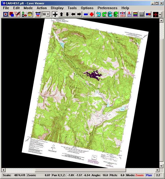
This image illustrates a cave locked to a USGS 7.5 minute topographic map. The image also illustrates how the images rotates and scales as the cave is rotated and scaled.
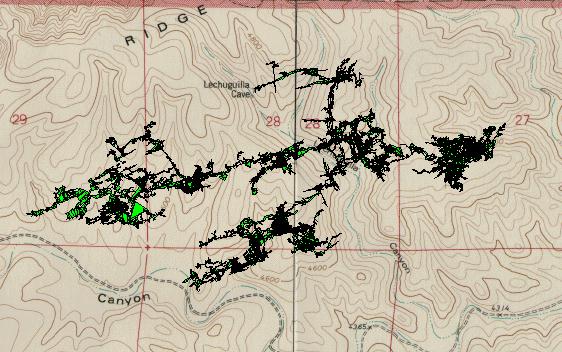
. This image was created by the Window COMPASS viewer. It illustrates Compass's ability to read bitmap images and use them as a background for the plot. In this picture, the bitmap background is a USGS topographic map. The image consist the USGS topographic map around Lechuguilla Cave with the cave plotted on top. The bitmap background was scanned using a flat bed scanner. The cave was plotted using the solid wall modeling. The green coloring in the cave show the large rooms. On my DeskJet 855 printer, this prints out very nicely.

 
 Sponsored Links
Sponsored Links
 Sponsored Links
 Sponsored Links

<< Home

Custom Search